Trail Walking Besse-et-Saint-Anastaise - Sancy par Super-Besse - Photo
 tracegps
tracegps

User

© OpenStreetMap contributors
Length
Length
10 km
Max alt
Max alt
1862 m
Uphill gradient
Uphill gradient
693 m
Km-Effort
Km-Effort  
19.2 km
Min alt
Min alt
1288 m
Downhill gradient
Downhill gradient
693 m
Boucle
Boucle
Yes
Creation date :
2014-12-10 00:00:00.0
Updated on :
2014-12-10 00:00:00.0

(1 Reviews)

Walking
Walking
3h00
Difficulty : Difficult

Scan this QR Code to open this trail in the SityTrail application

FREE GPS app for hiking

Logo SityTrail SityTrail

IGN / Geographical institutes

Download SityTrail from the App Store Download SityTrail from Google Play

Logo SityTrail SityTrail World

The world is yours!

Download SityTrail from the App Store Download SityTrail from Google Play Download SityTrail on Huawei AppGallery

About

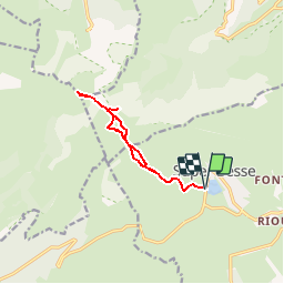
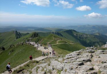
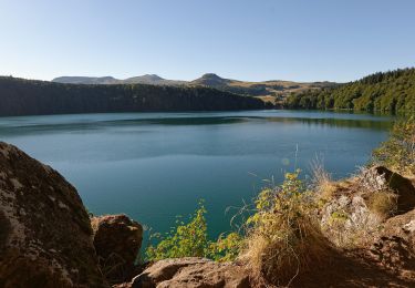
Trail Walking of 10 km to be discovered at Auvergne-Rhône-Alpes, Puy-de-Dôme, Besse-et-Saint-Anastaise. This trail is proposed by tracegps.

Description

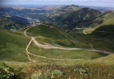
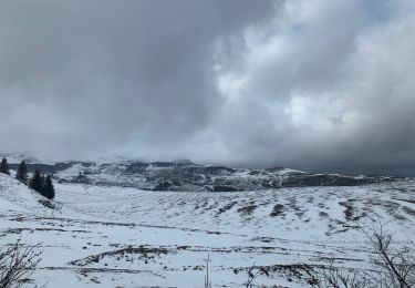
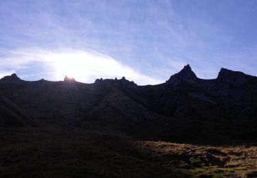
Départ en bas de la piste familiale à coté du petit chalet. Suivre la piste puis le chemin impossible à rater. Première partie plutôt monotone mais la vue sur Super-Besse est grandiose. Col de la Cabanne puis approche du pic du Sancy par un sentier en zig zag dans la pierraille. Pour profiter du panorama, préférer des conditions météo optimum. Prendre garde aussi au vent car le col de la Cabanne et l’arrête sommital deviennent dangereux.

Elevation profile

Photos

Positioning

Country:
France
Region :
Auvergne-Rhône-Alpes
Department/Province :
Puy-de-Dôme
Municipality :
Besse-et-Saint-Anastaise
Location:
Unknown
Start:(UTM)
488534 ; 5039329 (31T) N.

Comments

Please log in to post a review or rate the element


Trails nearby

Trail Walking Mont-Dore - Montée au sommet du Puy de Sancy - Photo
Walking
GUIDE
pscheven

Walking

Easy
(1)
Mont-Dore, Auvergne-Rhône-Alpes, Puy-de-Dôme, France
1.4 km | 2.7 km-effort
40min
Yes
Trail Walking Besse-et-Saint-Anastaise - Les 3 lacs et la cascade  - Photo
Walking
zefreefly

Walking

Easy
(1)
Besse-et-Saint-Anastaise, Auvergne-Rhône-Alpes, Puy-de-Dôme, France
19 km | 25 km-effort
7h 24min
Yes
Trail Walking Mont-Dore - Mont_Dore_Puy_Sancy - Photo
Walking
GUIDE
jagarnier

Walking

Difficult
(1)
Mont-Dore, Auvergne-Rhône-Alpes, Puy-de-Dôme, France
6.8 km | 13.9 km-effort
2h 0min
Yes
Trail Walking Chambon-sur-Lac - Chambon_Vallee_Chaudefour_2 - Photo
Walking
GUIDE
jagarnier

Walking

Difficult
(1)
Chambon-sur-Lac, Auvergne-Rhône-Alpes, Puy-de-Dôme, France
15 km | 26 km-effort
4h 30min
Yes
Trail Walking Mont-Dore - le sancy du mont dore par le côté ouest puis revenir par le côté est.  - Photo
Walking
loloetienne

Walking

Difficult
(2)
Mont-Dore, Auvergne-Rhône-Alpes, Puy-de-Dôme, France
8.2 km | 15.4 km-effort
3h 5min
Yes
Trail On foot Besse-et-Saint-Anastaise - La Chapelle de Vassivière - Photo
On foot
PRO

On foot

Easy
Besse-et-Saint-Anastaise, Auvergne-Rhône-Alpes, Puy-de-Dôme, France
11.6 km | 16.7 km-effort
3h 47min
Yes
Trail On foot Besse-et-Saint-Anastaise - Le puy de Montchal et le Lac Pavin - Photo
On foot
PRO

On foot

Easy
Besse-et-Saint-Anastaise, Auvergne-Rhône-Alpes, Puy-de-Dôme, France
6.9 km | 10 km-effort
2h 16min
Yes
Trail On foot Mont-Dore - Le Puy de Sancy - Photo
On foot
PRO

On foot

Easy
Mont-Dore, Auvergne-Rhône-Alpes, Puy-de-Dôme, France
6.9 km | 14 km-effort
3h 10min
Yes
Trail On foot Besse-et-Saint-Anastaise - Ballade autour du Pavin - Photo
On foot
PRO

On foot

Easy
Besse-et-Saint-Anastaise, Auvergne-Rhône-Alpes, Puy-de-Dôme, France
4 km | 5.7 km-effort
1h 17min
No


Close
My subscriptions