


croix de vinobre saint sernin

raab
User
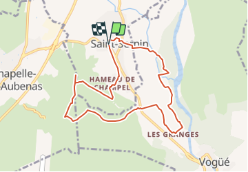

Length
9.4 km

Max alt
359 m

Uphill gradient
240 m
Km-Effort
12.6 km

Min alt
152 m

Downhill gradient
239 m
Boucle
Yes
Creation date :
2022-03-19 17:08:23.755
Updated on :
2022-03-19 17:19:17.932
2h18
Difficulty : Medium

FREE GPS app for hiking
 SityTrail
IGN / Geographical institutes
SityTrail Plus
The world is yours!
About
Trail Walking of 9.4 km to be discovered at Auvergne-Rhône-Alpes, Ardèche, Saint-Sernin. This trail is proposed by raab.
Positioning
Country:
France
Region :
Auvergne-Rhône-Alpes
Department/Province :
Ardèche
Municipality :
Saint-Sernin
Location:
Unknown
Start:(Dec)
Start:(UTM)
610315 ; 4936206 (31T) N.
Comments