


La randonnée du Potier st Uze

alinetpierre
User
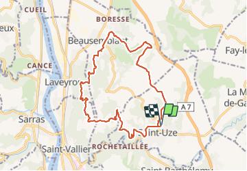

Length
18.2 km

Max alt
357 m

Uphill gradient
524 m
Km-Effort
25 km

Min alt
150 m

Downhill gradient
526 m
Boucle
Yes
Creation date :
2022-03-20 07:04:48.0
Updated on :
2022-03-20 10:48:12.871
3h30
Difficulty : Easy

FREE GPS app for hiking
 SityTrail
IGN / Geographical institutes
SityTrail Plus
The world is yours!
About
Trail Walking of 18.2 km to be discovered at Auvergne-Rhône-Alpes, Drôme, Saint-Uze. This trail is proposed by alinetpierre.
Description
Association de st Uze
Positioning
Country:
France
Region :
Auvergne-Rhône-Alpes
Department/Province :
Drôme
Municipality :
Saint-Uze
Location:
Unknown
Start:(Dec)
Start:(UTM)
646377 ; 5005384 (31T) N.
Comments