


QJ3Y1ob38mw

Linerou
User

Length
10.6 km

Max alt
240 m

Uphill gradient
202 m
Km-Effort
13.3 km

Min alt
115 m

Downhill gradient
202 m
Boucle
Yes
Creation date :
2022-03-20 15:10:43.493
Updated on :
2022-03-20 15:13:05.424
3h00
Difficulty : Medium

FREE GPS app for hiking
 SityTrail
IGN / Geographical institutes
SityTrail Plus
The world is yours!
About
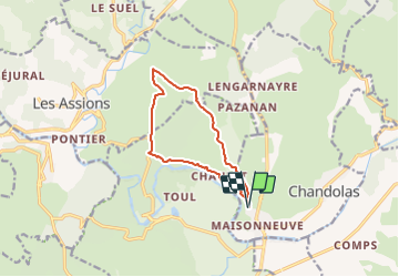
Trail Walking of 10.6 km to be discovered at Auvergne-Rhône-Alpes, Ardèche, Chandolas. This trail is proposed by Linerou.
Points of interest


Positioning
Country:
France
Region :
Auvergne-Rhône-Alpes
Department/Province :
Ardèche
Municipality :
Chandolas
Location:
Unknown
Start:(Dec)
Start:(UTM)
597865 ; 4916849 (31T) N.
Comments