


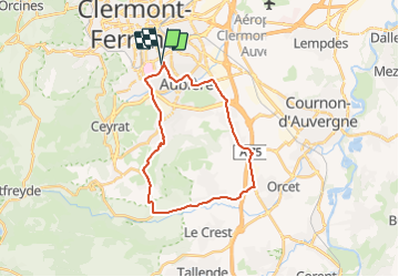
Clermont / Romagnat / Chanonat / La Roche Blanche / Pérignat / Clermont

PsyPezman
User

Length
24 km

Max alt
659 m

Uphill gradient
425 m
Km-Effort
30 km

Min alt
346 m

Downhill gradient
427 m
Boucle
Yes
Creation date :
2022-03-21 15:59:04.652
Updated on :
2022-03-23 20:32:53.942
1h16
Difficulty : Medium

FREE GPS app for hiking
 SityTrail
IGN / Geographical institutes
SityTrail Plus
The world is yours!
About
Trail Road bike of 24 km to be discovered at Auvergne-Rhône-Alpes, Puy-de-Dôme, Clermont-Ferrand. This trail is proposed by PsyPezman.
Positioning
Country:
France
Region :
Auvergne-Rhône-Alpes
Department/Province :
Puy-de-Dôme
Municipality :
Clermont-Ferrand
Location:
Unknown
Start:(Dec)
Start:(UTM)
507715 ; 5067349 (31T) N.
Comments