


pas de l'écho

philou68
User

Length
10.2 km

Max alt
610 m

Uphill gradient
398 m
Km-Effort
15.5 km

Min alt
267 m

Downhill gradient
401 m
Boucle
Yes
Creation date :
2022-03-23 09:11:11.725
Updated on :
2022-03-23 14:07:49.269
4h55
Difficulty : Easy

FREE GPS app for hiking
 SityTrail
IGN / Geographical institutes
SityTrail Plus
The world is yours!
About
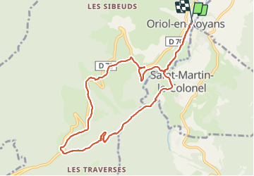
Trail Walking of 10.2 km to be discovered at Auvergne-Rhône-Alpes, Drôme, Oriol-en-Royans. This trail is proposed by philou68.
Description
Oriol en royans
Positioning
Country:
France
Region :
Auvergne-Rhône-Alpes
Department/Province :
Drôme
Municipality :
Oriol-en-Royans
Location:
Unknown
Start:(Dec)
Start:(UTM)
679323 ; 4985094 (31T) N.
Comments