


Draveil bord de Seine 21km

jeanmarcMasson
User GUIDE
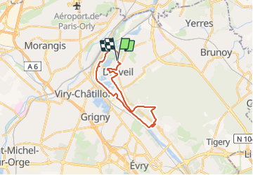

Length
21 km

Max alt
93 m

Uphill gradient
200 m
Km-Effort
24 km

Min alt
26 m

Downhill gradient
200 m
Boucle
Yes
Creation date :
2022-03-23 08:30:13.988
Updated on :
2022-03-23 14:29:37.291
4h39
Difficulty : Very difficult

FREE GPS app for hiking
 SityTrail
IGN / Geographical institutes
SityTrail Plus
The world is yours!
About
Trail Walking of 21 km to be discovered at Ile-de-France, Essonne, Draveil. This trail is proposed by jeanmarcMasson.
Positioning
Country:
France
Region :
Ile-de-France
Department/Province :
Essonne
Municipality :
Draveil
Location:
Unknown
Start:(Dec)
Start:(UTM)
456414 ; 5393426 (31U) N.
Comments