


reco trace VTT

CDSM 55
User

Length
29 km

Max alt
438 m

Uphill gradient
512 m
Km-Effort
35 km

Min alt
293 m

Downhill gradient
507 m
Boucle
Yes
Creation date :
2022-03-23 14:13:48.318
Updated on :
2022-03-24 05:25:20.116
2h20
Difficulty : Difficult

FREE GPS app for hiking
 SityTrail
IGN / Geographical institutes
SityTrail Plus
The world is yours!
About
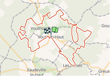
Trail Mountain bike of 29 km to be discovered at Grand Est, Meuse, Vouthon-Haut. This trail is proposed by CDSM 55.
Description
boucle non terminée petit bug
29.5 km au total
Photos


Positioning
Country:
France
Region :
Grand Est
Department/Province :
Meuse
Municipality :
Vouthon-Haut
Location:
Unknown
Start:(Dec)
Start:(UTM)
693442 ; 5372597 (31U) N.
Comments