Trail Mountain bike Plougonver - Autour de Plougonver - Photo

Autour de Plougonver

 tracegps
tracegps

User

© OpenStreetMap contributors
Length
Length
6.6 km
Max alt
Max alt
268 m
Uphill gradient
Uphill gradient
108 m
Km-Effort
Km-Effort  
8 km
Min alt
Min alt
213 m
Downhill gradient
Downhill gradient
109 m
Boucle
Boucle
Yes
Creation date :
2014-12-10 00:00:00.0
Updated on :
2014-12-10 00:00:00.0

(0 Reviews)

Mountain bike
Mountain bike
45m
Difficulty : Easy

Scan this QR Code to open this trail in the SityTrail application

FREE GPS app for hiking

Logo SityTrail SityTrail

IGN / Geographical institutes

Download SityTrail from the App Store Download SityTrail from Google Play

Logo SityTrail SityTrail World

The world is yours!

Download SityTrail from the App Store Download SityTrail from Google Play Download SityTrail on Huawei AppGallery

About

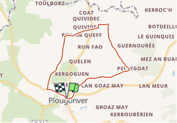
Trail Mountain bike of 6.6 km to be discovered at Brittany, Côtes-d'Armor, Plougonver. This trail is proposed by tracegps.

Description

Circuit très facile, familial, moitié route moitié chemin au départ de la place de l'église de Plougonver. Balisage de très bonne qualité.

Elevation profile

Photos

Positioning

Country:
France
Region :
Brittany
Department/Province :
Côtes-d'Armor
Municipality :
Plougonver
Location:
Unknown
Start:(UTM)
472017 ; 5370163 (30U) N.

Trails nearby

Trail Mountain bike Loc-Envel - Château de Coat an Noz - Loc Envel  - Photo
Mountain bike
tracegps

Mountain bike

Easy
Loc-Envel, Brittany, Côtes-d'Armor, France
6.7 km | 8.2 km-effort
45min
Yes
Trail Walking Loc-Envel - Loc Enveloppe - Photo
Walking
0658294C

Walking

Difficult
Loc-Envel, Brittany, Côtes-d'Armor, France
10.3 km | 13.2 km-effort
3h 5min
Yes


Close
My subscriptions