


Resteigne

r.genette
User
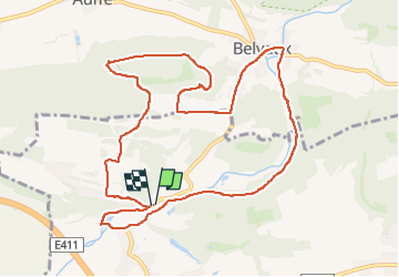

Length
10.8 km

Max alt
288 m

Uphill gradient
202 m
Km-Effort
13.5 km

Min alt
170 m

Downhill gradient
200 m
Boucle
Yes
Creation date :
2022-03-24 12:23:34.751
Updated on :
2023-03-24 13:12:02.266
2h39
Difficulty : Easy

FREE GPS app for hiking
 SityTrail
IGN / Geographical institutes
SityTrail Plus
The world is yours!
About
Trail Walking of 10.8 km to be discovered at Wallonia, Luxembourg, Tellin. This trail is proposed by r.genette.
Description
À faire
Positioning
Country:
Belgium
Region :
Wallonia
Department/Province :
Luxembourg
Municipality :
Tellin
Location:
Unknown
Start:(Dec)
Start:(UTM)
655704 ; 5551058 (31U) N.
Comments