Trail Hybrid bike Robion - MAS HONORAT Boucle 35 Kms vers Le Thor  - Photo

MAS HONORAT Boucle 35 Kms vers Le Thor

 denel
denel

User

© OpenStreetMap contributors
Length
Length
35 km
Max alt
Max alt
100 m
Uphill gradient
Uphill gradient
165 m
Km-Effort
Km-Effort  
37 km
Min alt
Min alt
52 m
Downhill gradient
Downhill gradient
167 m
Boucle
Boucle
No
Creation date :
2022-03-24 14:44:52.134
Updated on :
2022-03-24 22:00:19.136

(0 Reviews)

Hybrid bike
Hybrid bike
3h10
Difficulty : Easy

Scan this QR Code to open this trail in the SityTrail application

FREE GPS app for hiking

Logo SityTrail SityTrail

IGN / Geographical institutes

Download SityTrail from the App Store Download SityTrail from Google Play

Logo SityTrail SityTrail World

The world is yours!

Download SityTrail from the App Store Download SityTrail from Google Play Download SityTrail on Huawei AppGallery

About

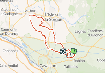
Trail Hybrid bike of 35 km to be discovered at Provence-Alpes-Côte d'Azur, Vaucluse, Robion. This trail is proposed by denel.

Description

Ballade Gravel à travers les champs de culture arboricole et de la campagne avoisinante.
Succession de route et de chemins

Elevation profile

Positioning

Country:
France
Region :
Provence-Alpes-Côte d'Azur
Department/Province :
Vaucluse
Municipality :
Robion
Location:
Unknown
Start:(UTM)
667989 ; 4857304 (31T) N.

Trails nearby

Trail Walking Robion - petit luberon - Photo
Walking
GUIDE
nadinebondoux

Walking

Difficult
(1)
Robion, Provence-Alpes-Côte d'Azur, Vaucluse, France
16.7 km | 27 km-effort
6h 23min
Yes
Trail Cycle Cavaillon - Autour du Luberon à vélo - Photo
Cycle
GUIDE+

Cycle

Difficult
(4)
Cavaillon, Provence-Alpes-Côte d'Azur, Vaucluse, France
236 km | 285 km-effort
15h 46min
Yes
Trail Cycle Cavaillon - Parcours n°3 - Cavaillon - Photo
Cycle
GUIDE+

Cycle

Easy
(2)
Cavaillon, Provence-Alpes-Côte d'Azur, Vaucluse, France
45 km | 50 km-effort
2h 55min
No
Trail Cycle Cavaillon - Parcours n°1 - Cavaillon - Photo
Cycle
GUIDE+

Cycle

Difficult
(2)
Cavaillon, Provence-Alpes-Côte d'Azur, Vaucluse, France
33 km | 41 km-effort
2h 21min
Yes
Trail Walking Taillades - Par la Gorge de Badarel et les Rochers de Baude - Photo
Walking
tracegps

Walking

Medium
(3)
Taillades, Provence-Alpes-Côte d'Azur, Vaucluse, France
8 km | 14.7 km-effort
4h 0min
Yes
Trail Walking Taillades - taillades - Photo
Walking
fireman84

Walking

Very easy
(1)
Taillades, Provence-Alpes-Côte d'Azur, Vaucluse, France
7.6 km | 9.8 km-effort
1h 36min
Yes
Trail Walking Lagnes - Lagnes - La Tête du Soldat - Mur de la Peste - Photo
Walking
tracegps

Walking

Medium
(2)
Lagnes, Provence-Alpes-Côte d'Azur, Vaucluse, France
11.2 km | 16 km-effort
4h 30min
Yes
Trail Walking Taillades - Les Taillades-De la source du Boulon au Castelas - Gorge de Badarel sous la neige - Photo
Walking
tracegps

Walking

Difficult
(1)
Taillades, Provence-Alpes-Côte d'Azur, Vaucluse, France
7 km | 10.8 km-effort
3h 0min
Yes
Trail Mountain bike Maubec - Luberon - Grande Traversée de Vaucluse - de Maubec / Robion à Mérindol - Photo
Mountain bike
GUIDE+

Mountain bike

Difficult
(1)
Maubec, Provence-Alpes-Côte d'Azur, Vaucluse, France
32 km | 42 km-effort
2h 47min
No


Close
My subscriptions