


2022 02 Mennecy T 1

michel1025
User
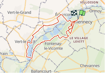

Length
19.1 km

Max alt
93 m

Uphill gradient
196 m
Km-Effort
22 km

Min alt
44 m

Downhill gradient
196 m
Boucle
Yes
Creation date :
2022-03-26 09:03:59.0
Updated on :
2022-03-26 14:38:27.531
4h23
Difficulty : Very difficult

FREE GPS app for hiking
 SityTrail
IGN / Geographical institutes
SityTrail Plus
The world is yours!
About
Trail Walking of 19.1 km to be discovered at Ile-de-France, Essonne, Mennecy. This trail is proposed by michel1025.
Positioning
Country:
France
Region :
Ile-de-France
Department/Province :
Essonne
Municipality :
Mennecy
Location:
Unknown
Start:(Dec)
Start:(UTM)
457879 ; 5379628 (31U) N.
Comments