


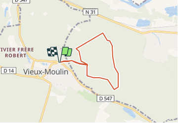
mont saint marc vieux moulin

NESTOR2714
User

Length
5.5 km

Max alt
133 m

Uphill gradient
121 m
Km-Effort
7.1 km

Min alt
56 m

Downhill gradient
122 m
Boucle
Yes
Creation date :
2022-03-26 18:54:21.669
Updated on :
2022-03-26 18:55:19.231
1h37
Difficulty : Medium

FREE GPS app for hiking
 SityTrail
IGN / Geographical institutes
SityTrail Plus
The world is yours!
About
Trail Walking of 5.5 km to be discovered at Hauts-de-France, Oise, Vieux-Moulin. This trail is proposed by NESTOR2714.
Positioning
Country:
France
Region :
Hauts-de-France
Department/Province :
Oise
Municipality :
Vieux-Moulin
Location:
Unknown
Start:(Dec)
Start:(UTM)
495268 ; 5471425 (31U) N.
Comments