


mont saint marc 2

NESTOR2714
User
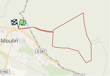

Length
4.4 km

Max alt
133 m

Uphill gradient
109 m
Km-Effort
5.9 km

Min alt
56 m

Downhill gradient
109 m
Boucle
Yes
Creation date :
2022-03-26 18:58:29.503
Updated on :
2022-03-26 18:59:07.798
1h20
Difficulty : Easy

FREE GPS app for hiking
 SityTrail
IGN / Geographical institutes
SityTrail Plus
The world is yours!
About
Trail Walking of 4.4 km to be discovered at Hauts-de-France, Oise, Vieux-Moulin. This trail is proposed by NESTOR2714.
Positioning
Country:
France
Region :
Hauts-de-France
Department/Province :
Oise
Municipality :
Vieux-Moulin
Location:
Unknown
Start:(Dec)
Start:(UTM)
495259 ; 5471427 (31U) N.
Comments