


montreux Barbas harbouey

Titinechris
User
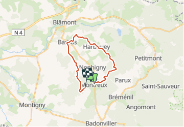

Length
17.6 km

Max alt
346 m

Uphill gradient
223 m
Km-Effort
21 km

Min alt
255 m

Downhill gradient
266 m
Boucle
No
Creation date :
2022-03-27 09:43:07.174
Updated on :
2022-03-27 12:15:02.678
2h31
Difficulty : Easy

FREE GPS app for hiking
 SityTrail
IGN / Geographical institutes
SityTrail Plus
The world is yours!
About
Trail Running of 17.6 km to be discovered at Grand Est, Meurthe-et-Moselle, Neuviller-lès-Badonviller. This trail is proposed by Titinechris.
Positioning
Country:
France
Region :
Grand Est
Department/Province :
Meurthe-et-Moselle
Municipality :
Neuviller-lès-Badonviller
Location:
Unknown
Start:(Dec)
Start:(UTM)
342878 ; 5377649 (32U) N.
Comments