


Strée - Villers le temple - Outrelouxhe

tatous
User
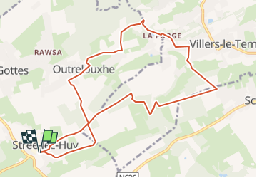

Length
10.1 km

Max alt
272 m

Uphill gradient
191 m
Km-Effort
12.6 km

Min alt
185 m

Downhill gradient
191 m
Boucle
Yes
Creation date :
2022-03-27 16:02:30.311
Updated on :
2022-03-27 16:04:22.288
0m
Difficulty : Very easy

FREE GPS app for hiking
 SityTrail
IGN / Geographical institutes
SityTrail Plus
The world is yours!
About
Trail Nordic walking of 10.1 km to be discovered at Wallonia, Liège, Modave. This trail is proposed by tatous.
Positioning
Country:
Belgium
Region :
Wallonia
Department/Province :
Liège
Municipality :
Modave
Location:
Unknown
Start:(Dec)
Start:(UTM)
664915 ; 5595844 (31U) N.
Comments