


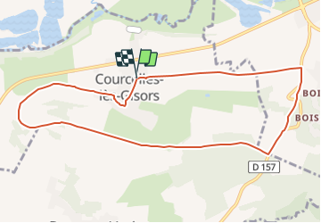
Courcelles la cote Perreuse

serge.guerroult
User

Length
9.6 km

Max alt
149 m

Uphill gradient
112 m
Km-Effort
11.1 km

Min alt
68 m

Downhill gradient
111 m
Boucle
Yes
Creation date :
2022-03-27 17:51:36.231
Updated on :
2022-03-27 18:00:52.804
0m
Difficulty : Very easy

FREE GPS app for hiking
 SityTrail
IGN / Geographical institutes
SityTrail Plus
The world is yours!
About
Trail Nordic walking of 9.6 km to be discovered at Hauts-de-France, Oise, Courcelles-lès-Gisors. This trail is proposed by serge.guerroult.
Positioning
Country:
France
Region :
Hauts-de-France
Department/Province :
Oise
Municipality :
Courcelles-lès-Gisors
Location:
Unknown
Start:(Dec)
Start:(UTM)
408577 ; 5457223 (31U) N.
Comments