


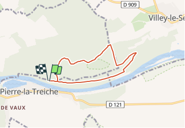
Rando spéléo CE2/CM1/CM2-Poudrière et Chemin des grottes

nicolas54230
User

Length
6 km

Max alt
310 m

Uphill gradient
112 m
Km-Effort
7.5 km

Min alt
217 m

Downhill gradient
112 m
Boucle
Yes
Creation date :
2022-03-28 07:17:02.986
Updated on :
2022-03-28 07:36:29.96
1h41
Difficulty : Medium

FREE GPS app for hiking
 SityTrail
IGN / Geographical institutes
SityTrail Plus
The world is yours!
About
Trail Walking of 6 km to be discovered at Grand Est, Meurthe-et-Moselle, Pierre-la-Treiche. This trail is proposed by nicolas54230.
Positioning
Country:
France
Region :
Grand Est
Department/Province :
Meurthe-et-Moselle
Municipality :
Pierre-la-Treiche
Location:
Unknown
Start:(Dec)
Start:(UTM)
716359 ; 5392214 (31U) N.
Comments