


fontvieille

ajasse
User
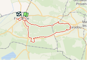

Length
21 km

Max alt
108 m

Uphill gradient
261 m
Km-Effort
24 km

Min alt
7 m

Downhill gradient
261 m
Boucle
Yes
Creation date :
2022-03-28 07:34:24.384
Updated on :
2022-03-28 14:40:58.073
5h17
Difficulty : Medium

FREE GPS app for hiking
 SityTrail
IGN / Geographical institutes
SityTrail Plus
The world is yours!
About
Trail Walking of 21 km to be discovered at Provence-Alpes-Côte d'Azur, Bouches-du-Rhône, Fontvieille. This trail is proposed by ajasse.
Positioning
Country:
France
Region :
Provence-Alpes-Côte d'Azur
Department/Province :
Bouches-du-Rhône
Municipality :
Fontvieille
Location:
Unknown
Start:(Dec)
Start:(UTM)
637671 ; 4842742 (31T) N.
Comments