


malaucene ,lac du Paty

patourad
User
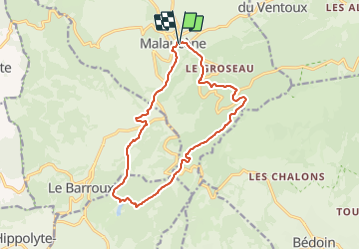

Length
15.1 km

Max alt
699 m

Uphill gradient
587 m
Km-Effort
23 km

Min alt
299 m

Downhill gradient
589 m
Boucle
Yes
Creation date :
2022-03-29 13:00:39.895
Updated on :
2022-03-29 13:01:39.164
5h13
Difficulty : Very difficult

FREE GPS app for hiking
 SityTrail
IGN / Geographical institutes
SityTrail Plus
The world is yours!
About
Trail Walking of 15.1 km to be discovered at Provence-Alpes-Côte d'Azur, Vaucluse, Malaucène. This trail is proposed by patourad.
Description
randonnée g1
Positioning
Country:
France
Region :
Provence-Alpes-Côte d'Azur
Department/Province :
Vaucluse
Municipality :
Malaucène
Location:
Unknown
Start:(Dec)
Start:(UTM)
670627 ; 4893312 (31T) N.
Comments