


Azy gr16

vanessadebreux
User
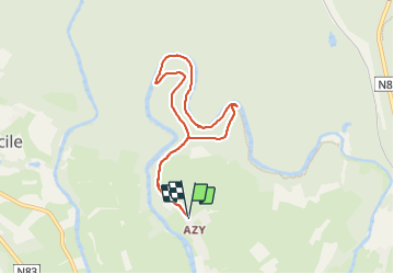

Length
6.5 km

Max alt
352 m

Uphill gradient
138 m
Km-Effort
8.4 km

Min alt
291 m

Downhill gradient
138 m
Boucle
Yes
Creation date :
2022-03-29 15:29:24.0
Updated on :
2022-03-29 16:53:35.862
1h23
Difficulty : Medium

FREE GPS app for hiking
 SityTrail
IGN / Geographical institutes
SityTrail Plus
The world is yours!
About
Trail Walking of 6.5 km to be discovered at Wallonia, Luxembourg, Florenville. This trail is proposed by vanessadebreux.
Positioning
Country:
Belgium
Region :
Wallonia
Department/Province :
Luxembourg
Municipality :
Florenville
Location:
Chassepierre
Start:(Dec)
Start:(UTM)
664147 ; 5510134 (31U) N.
Comments