


La Chapelle Saint Roch Pont d'Ouilly

michelberrier
User
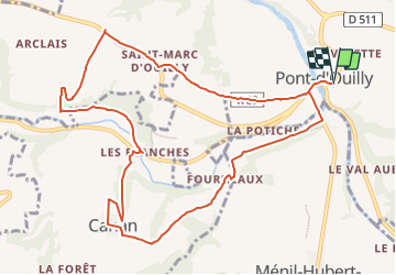

Length
11.2 km

Max alt
190 m

Uphill gradient
306 m
Km-Effort
15.3 km

Min alt
47 m

Downhill gradient
304 m
Boucle
Yes
Creation date :
2022-03-30 13:36:06.191
Updated on :
2022-03-30 13:36:37.9
3h28
Difficulty : Easy

FREE GPS app for hiking
 SityTrail
IGN / Geographical institutes
SityTrail Plus
The world is yours!
About
Trail On foot of 11.2 km to be discovered at Normandy, Calvados, Pont-d'Ouilly. This trail is proposed by michelberrier.
Positioning
Country:
France
Region :
Normandy
Department/Province :
Calvados
Municipality :
Pont-d'Ouilly
Location:
Unknown
Start:(Dec)
Start:(UTM)
690037 ; 5416644 (30U) N.
Comments