


Col de Cize 31/03/22

Linerou
User
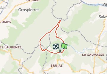

Length
10.5 km

Max alt
545 m

Uphill gradient
402 m
Km-Effort
15.8 km

Min alt
220 m

Downhill gradient
397 m
Boucle
Yes
Creation date :
2022-03-31 08:16:56.558
Updated on :
2022-03-31 13:19:44.439
3h17
Difficulty : Medium

FREE GPS app for hiking
 SityTrail
IGN / Geographical institutes
SityTrail Plus
The world is yours!
About
Trail Walking of 10.5 km to be discovered at Auvergne-Rhône-Alpes, Ardèche, Vagnas. This trail is proposed by Linerou.
Positioning
Country:
France
Region :
Auvergne-Rhône-Alpes
Department/Province :
Ardèche
Municipality :
Vagnas
Location:
Unknown
Start:(Dec)
Start:(UTM)
605643 ; 4913197 (31T) N.
Comments
Superbe vue