


Vauvert

Dupuybadonniere
User
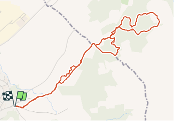

Length
6.9 km

Max alt
105 m

Uphill gradient
115 m
Km-Effort
8.5 km

Min alt
40 m

Downhill gradient
114 m
Boucle
Yes
Creation date :
2022-04-01 12:18:50.761
Updated on :
2022-04-01 14:24:42.613
1h51
Difficulty : Medium

FREE GPS app for hiking
 SityTrail
IGN / Geographical institutes
SityTrail Plus
The world is yours!
About
Trail Walking of 6.9 km to be discovered at Occitania, Gard, Vauvert. This trail is proposed by Dupuybadonniere.
Positioning
Country:
France
Region :
Occitania
Department/Province :
Gard
Municipality :
Vauvert
Location:
Unknown
Start:(Dec)
Start:(UTM)
603695 ; 4838934 (31T) N.
Comments