


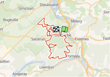
La Marbichonne

PhilippeC54
User

Length
43 km

Max alt
354 m

Uphill gradient
807 m
Km-Effort
53 km

Min alt
199 m

Downhill gradient
805 m
Boucle
Yes
Creation date :
2022-04-03 06:11:39.094
Updated on :
2022-04-03 10:28:49.719
3h23
Difficulty : Difficult

FREE GPS app for hiking
 SityTrail
IGN / Geographical institutes
SityTrail Plus
The world is yours!
About
Trail Mountain bike of 43 km to be discovered at Grand Est, Meurthe-et-Moselle, Marbache. This trail is proposed by PhilippeC54.
Positioning
Country:
France
Region :
Grand Est
Department/Province :
Meurthe-et-Moselle
Municipality :
Marbache
Location:
Unknown
Start:(Dec)
Start:(UTM)
286643 ; 5408738 (32U) N.
Comments