


2022-04-04_09h55m35_61-Conde_Ifs-10178491-1649058927-200

phi14
User
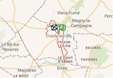

Length
9.4 km

Max alt
68 m

Uphill gradient
100 m
Km-Effort
10.7 km

Min alt
29 m

Downhill gradient
100 m
Boucle
Yes
Creation date :
2022-04-04 07:55:36.202
Updated on :
2022-04-04 07:56:58.542
0m
Difficulty : Easy

FREE GPS app for hiking
 SityTrail
IGN / Geographical institutes
SityTrail Plus
The world is yours!
About
Trail Nordic walking of 9.4 km to be discovered at Normandy, Calvados, Condé-sur-Ifs. This trail is proposed by phi14.
Positioning
Country:
France
Region :
Normandy
Department/Province :
Calvados
Municipality :
Condé-sur-Ifs
Location:
Unknown
Start:(Dec)
Start:(UTM)
709868 ; 5436063 (30U) N.
Comments