


Boury-Monbines le Breuil

serge.guerroult
User
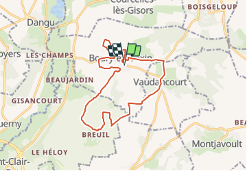

Length
14.5 km

Max alt
138 m

Uphill gradient
205 m
Km-Effort
17.2 km

Min alt
52 m

Downhill gradient
205 m
Boucle
Yes
Creation date :
2022-04-04 11:13:55.336
Updated on :
2022-04-05 10:21:35.235
3h44
Difficulty : Difficult
0m
Difficulty : Very easy

FREE GPS app for hiking
 SityTrail
IGN / Geographical institutes
SityTrail Plus
The world is yours!
About
Trail Walking of 14.5 km to be discovered at Hauts-de-France, Oise, Boury-en-Vexin. This trail is proposed by serge.guerroult.
Positioning
Country:
France
Region :
Hauts-de-France
Department/Province :
Oise
Municipality :
Boury-en-Vexin
Location:
Unknown
Start:(Dec)
Start:(UTM)
408138 ; 5454883 (31U) N.
Comments