


HONFLEUR 11,250 KM

Laurent53
User
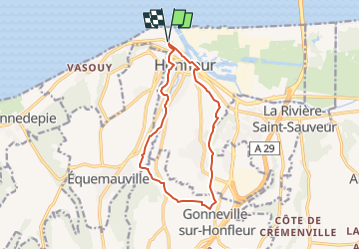

Length
11.3 km

Max alt
123 m

Uphill gradient
203 m
Km-Effort
14 km

Min alt
2 m

Downhill gradient
203 m
Boucle
Yes
Creation date :
2022-04-04 14:50:48.888
Updated on :
2022-09-03 08:27:15.22
4h22
Difficulty : Very easy

FREE GPS app for hiking
 SityTrail
IGN / Geographical institutes
SityTrail Plus
The world is yours!
About
Trail On foot of 11.3 km to be discovered at Normandy, Calvados, Honfleur. This trail is proposed by Laurent53.
Positioning
Country:
France
Region :
Normandy
Department/Province :
Calvados
Municipality :
Honfleur
Location:
Unknown
Start:(Dec)
Start:(UTM)
299014 ; 5478401 (31U) N.
Comments