


saint-Vrain

gdela
User
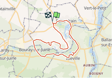

Length
16.4 km

Max alt
81 m

Uphill gradient
151 m
Km-Effort
18.5 km

Min alt
52 m

Downhill gradient
152 m
Boucle
Yes
Creation date :
2022-04-05 07:38:25.741
Updated on :
2022-04-06 15:14:40.069
3h28
Difficulty : Medium

FREE GPS app for hiking
 SityTrail
IGN / Geographical institutes
SityTrail Plus
The world is yours!
About
Trail Walking of 16.4 km to be discovered at Ile-de-France, Essonne, Saint-Vrain. This trail is proposed by gdela.
Positioning
Country:
France
Region :
Ile-de-France
Department/Province :
Essonne
Municipality :
Saint-Vrain
Location:
Unknown
Start:(Dec)
Start:(UTM)
449748 ; 5376653 (31U) N.
Comments