


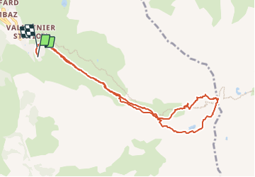
col des charmette (Valmeinier)

CABERMAT
User

Length
10.3 km

Max alt
2724 m

Uphill gradient
888 m
Km-Effort
22 km

Min alt
1831 m

Downhill gradient
877 m
Boucle
Yes
Creation date :
2022-04-05 07:10:46.414
Updated on :
2022-04-05 12:13:49.093
5h01
Difficulty : Very easy

FREE GPS app for hiking
 SityTrail
IGN / Geographical institutes
SityTrail Plus
The world is yours!
About
Trail Touring skiing of 10.3 km to be discovered at Auvergne-Rhône-Alpes, Savoy, Valmeinier. This trail is proposed by CABERMAT.
Positioning
Country:
France
Region :
Auvergne-Rhône-Alpes
Department/Province :
Savoy
Municipality :
Valmeinier
Location:
Unknown
Start:(Dec)
Start:(UTM)
303294 ; 5005022 (32T) N.
Comments