


Tarare

JacouBrijou
User
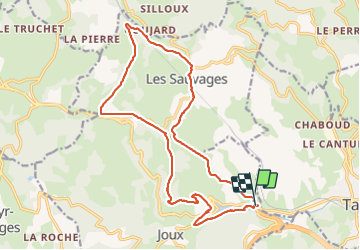

Length
19.2 km

Max alt
794 m

Uphill gradient
667 m
Km-Effort
28 km

Min alt
429 m

Downhill gradient
705 m
Boucle
Yes
Creation date :
2022-04-05 06:05:29.557
Updated on :
2022-04-05 13:10:22.823
7h02
Difficulty : Medium

FREE GPS app for hiking
 SityTrail
IGN / Geographical institutes
SityTrail Plus
The world is yours!
About
Trail Walking of 19.2 km to be discovered at Auvergne-Rhône-Alpes, Rhône, Joux. This trail is proposed by JacouBrijou.
Description
19 km
Positioning
Country:
France
Region :
Auvergne-Rhône-Alpes
Department/Province :
Rhône
Municipality :
Joux
Location:
Unknown
Start:(Dec)
Start:(UTM)
608509 ; 5083334 (31T) N.
Comments