


arsel Pegairolles de l esclette

labarone
User
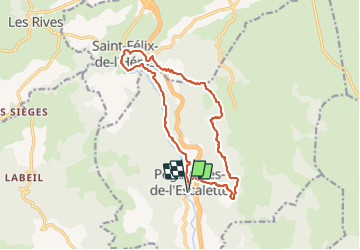

Length
16.9 km

Max alt
725 m

Uphill gradient
671 m
Km-Effort
26 km

Min alt
300 m

Downhill gradient
673 m
Boucle
Yes
Creation date :
2022-04-05 06:39:24.721
Updated on :
2022-04-05 13:26:07.095
6h02
Difficulty : Medium

FREE GPS app for hiking
 SityTrail
IGN / Geographical institutes
SityTrail Plus
The world is yours!
About
Trail Walking of 16.9 km to be discovered at Occitania, Hérault, Pégairolles-de-l'Escalette. This trail is proposed by labarone.
Description
belle rando
Photos


Positioning
Country:
France
Region :
Occitania
Department/Province :
Hérault
Municipality :
Pégairolles-de-l'Escalette
Location:
Unknown
Start:(Dec)
Start:(UTM)
525971 ; 4849714 (31T) N.
Comments