Billième G1

Valmeinier
User
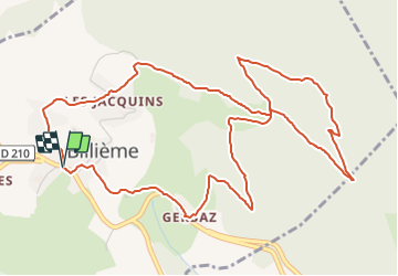

Length
7 km

Max alt
790 m

Uphill gradient
392 m
Km-Effort
12.2 km

Min alt
398 m

Downhill gradient
397 m
Boucle
Yes
Creation date :
2022-04-06 03:55:25.216
Updated on :
2022-04-06 03:55:25.216
2h46
Difficulty : Difficult

FREE GPS app for hiking
 SityTrail
IGN / Geographical institutes
SityTrail Plus
The world is yours!
About
Trail Walking of 7 km to be discovered at Auvergne-Rhône-Alpes, Savoy, Billième. This trail is proposed by Valmeinier.
Positioning
Country:
France
Region :
Auvergne-Rhône-Alpes
Department/Province :
Savoy
Municipality :
Billième
Location:
Unknown
Start:(Dec)
Start:(UTM)
718669 ; 5066695 (31T) N.
Comments