


ITI0352

jeanic63
User
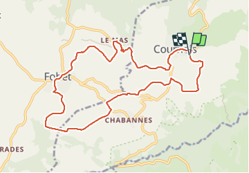

Length
10.7 km

Max alt
962 m

Uphill gradient
274 m
Km-Effort
14.4 km

Min alt
760 m

Downhill gradient
270 m
Boucle
Yes
Creation date :
2022-04-06 13:34:57.662
Updated on :
2022-04-07 09:22:07.825
3h16
Difficulty : Easy

FREE GPS app for hiking
 SityTrail
IGN / Geographical institutes
SityTrail Plus
The world is yours!
About
Trail On foot of 10.7 km to be discovered at Auvergne-Rhône-Alpes, Puy-de-Dôme, Cournols. This trail is proposed by jeanic63.
Description
départ Cournol vers l'école
Positioning
Country:
France
Region :
Auvergne-Rhône-Alpes
Department/Province :
Puy-de-Dôme
Municipality :
Cournols
Location:
Unknown
Start:(Dec)
Start:(UTM)
502760 ; 5054733 (31T) N.
Comments