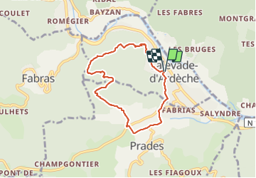
lalevade prades

raab
User

Length
6.6 km

Max alt
476 m

Uphill gradient
261 m
Km-Effort
10.1 km

Min alt
269 m

Downhill gradient
260 m
Boucle
Yes
Creation date :
2022-04-07 11:54:03.751
Updated on :
2022-04-07 15:06:01.616
3h11
Difficulty : Medium

FREE GPS app for hiking
 SityTrail
IGN / Geographical institutes
SityTrail Plus
The world is yours!
About
Trail Walking of 6.6 km to be discovered at Auvergne-Rhône-Alpes, Ardèche, Lalevade-d'Ardèche. This trail is proposed by raab.
Positioning
Country:
France
Region :
Auvergne-Rhône-Alpes
Department/Province :
Ardèche
Municipality :
Lalevade-d'Ardèche
Location:
Unknown
Start:(Dec)
Start:(UTM)
604701 ; 4945025 (31T) N.
Comments