


Le vésinet

JLKino
User
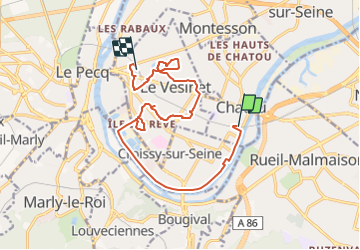

Length
14.5 km

Max alt
48 m

Uphill gradient
92 m
Km-Effort
15.7 km

Min alt
20 m

Downhill gradient
96 m
Boucle
No
Creation date :
2022-04-07 19:44:55.311
Updated on :
2022-04-07 19:45:32.228
3h34
Difficulty : Easy

FREE GPS app for hiking
 SityTrail
IGN / Geographical institutes
SityTrail Plus
The world is yours!
About
Trail On foot of 14.5 km to be discovered at Ile-de-France, Yvelines, Chatou. This trail is proposed by JLKino.
Positioning
Country:
France
Region :
Ile-de-France
Department/Province :
Yvelines
Municipality :
Chatou
Location:
Unknown
Start:(Dec)
Start:(UTM)
438142 ; 5415042 (31U) N.
Comments