


Villeneuve en Montagne Prédon/Les Chazeaux page132

grasgilbert
User
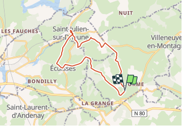

Length
13.4 km

Max alt
415 m

Uphill gradient
318 m
Km-Effort
17.6 km

Min alt
265 m

Downhill gradient
323 m
Boucle
Yes
Creation date :
2022-04-08 07:13:14.479
Updated on :
2022-04-08 07:17:35.17
4h00
Difficulty : Difficult

FREE GPS app for hiking
 SityTrail
IGN / Geographical institutes
SityTrail Plus
The world is yours!
About
Trail Walking of 13.4 km to be discovered at Bourgogne-Franche-Comté, Saône-et-Loire, Villeneuve-en-Montagne. This trail is proposed by grasgilbert.
Description
Départ La Chapelle de Villard
Positioning
Country:
France
Region :
Bourgogne-Franche-Comté
Department/Province :
Saône-et-Loire
Municipality :
Villeneuve-en-Montagne
Location:
Unknown
Start:(Dec)
Start:(UTM)
620730 ; 5178145 (31T) N.
Comments
bien