


randogps62-281

Blourouce
User

Length
11.5 km

Max alt
153 m

Uphill gradient
130 m
Km-Effort
13.2 km

Min alt
99 m

Downhill gradient
130 m
Boucle
Yes
Creation date :
2022-04-08 08:10:54.037
Updated on :
2022-04-08 08:18:58.604
2h59
Difficulty : Difficult

FREE GPS app for hiking
 SityTrail
IGN / Geographical institutes
SityTrail Plus
The world is yours!
About
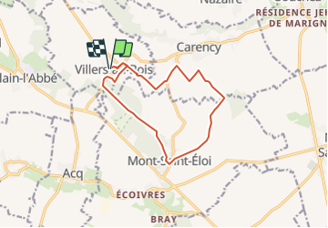
Trail Walking of 11.5 km to be discovered at Hauts-de-France, Pas-de-Calais, Villers-au-Bois. This trail is proposed by Blourouce.
Positioning
Country:
France
Region :
Hauts-de-France
Department/Province :
Pas-de-Calais
Municipality :
Villers-au-Bois
Location:
Unknown
Start:(Dec)
Start:(UTM)
476555 ; 5580221 (31U) N.
Comments