


rando morilles 1

Emmanuel Serafin
User

Length
3.9 km

Max alt
217 m

Uphill gradient
16 m
Km-Effort
4.1 km

Min alt
208 m

Downhill gradient
24 m
Boucle
No
Creation date :
2022-04-09 06:38:51.198
Updated on :
2022-04-09 16:54:44.478
10h14
Difficulty : Easy

FREE GPS app for hiking
 SityTrail
IGN / Geographical institutes
SityTrail Plus
The world is yours!
About
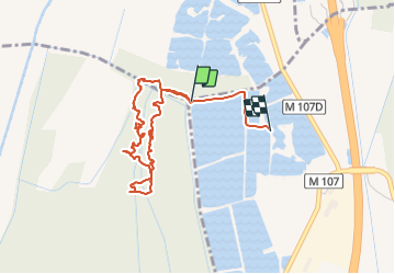
Trail Walking of 3.9 km to be discovered at Bourgogne-Franche-Comté, Côte-d'Or, Bressey-sur-Tille. This trail is proposed by Emmanuel Serafin.
Positioning
Country:
France
Region :
Bourgogne-Franche-Comté
Department/Province :
Côte-d'Or
Municipality :
Bressey-sur-Tille
Location:
Unknown
Start:(Dec)
Start:(UTM)
663249 ; 5242345 (31T) N.
Comments