


Talencieux randonnée de tous les vents

alinetpierre
User
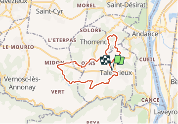

Length
14 km

Max alt
398 m

Uphill gradient
257 m
Km-Effort
17.4 km

Min alt
299 m

Downhill gradient
258 m
Boucle
Yes
Creation date :
2022-04-10 06:19:10.0
Updated on :
2022-04-10 09:13:26.759
2h42
Difficulty : Easy

FREE GPS app for hiking
 SityTrail
IGN / Geographical institutes
SityTrail Plus
The world is yours!
About
Trail Walking of 14 km to be discovered at Auvergne-Rhône-Alpes, Ardèche, Talencieux. This trail is proposed by alinetpierre.
Positioning
Country:
France
Region :
Auvergne-Rhône-Alpes
Department/Province :
Ardèche
Municipality :
Talencieux
Location:
Unknown
Start:(Dec)
Start:(UTM)
639438 ; 5009165 (31T) N.
Comments