


La ferte beauharnais Ouest

lemuid
User
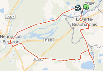

Length
12.4 km

Max alt
119 m

Uphill gradient
111 m
Km-Effort
13.8 km

Min alt
92 m

Downhill gradient
109 m
Boucle
Yes
Creation date :
2022-04-10 07:07:06.864
Updated on :
2022-04-10 12:01:18.023
2h39
Difficulty : Very easy

FREE GPS app for hiking
 SityTrail
IGN / Geographical institutes
SityTrail Plus
The world is yours!
About
Trail Walking of 12.4 km to be discovered at Centre-Loire Valley, Loir-et-Cher, Neung-sur-Beuvron. This trail is proposed by lemuid.
Positioning
Country:
France
Region :
Centre-Loire Valley
Department/Province :
Loir-et-Cher
Municipality :
Neung-sur-Beuvron
Location:
Unknown
Start:(Dec)
Start:(UTM)
413387 ; 5266365 (31T) N.
Comments