


Esterel - Sommet du Marsaou

aris
User
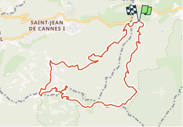

Length
13.7 km

Max alt
542 m

Uphill gradient
579 m
Km-Effort
21 km

Min alt
50 m

Downhill gradient
578 m
Boucle
Yes
Creation date :
2022-04-10 07:10:24.64
Updated on :
2022-04-10 16:33:19.217
7h01
Difficulty : Easy

FREE GPS app for hiking
 SityTrail
IGN / Geographical institutes
SityTrail Plus
The world is yours!
About
Trail Walking of 13.7 km to be discovered at Provence-Alpes-Côte d'Azur, Maritime Alps, Mandelieu-la-Napoule. This trail is proposed by aris.
Positioning
Country:
France
Region :
Provence-Alpes-Côte d'Azur
Department/Province :
Maritime Alps
Municipality :
Mandelieu-la-Napoule
Location:
Unknown
Start:(Dec)
Start:(UTM)
330121 ; 4820980 (32T) N.
Comments