


Honfleur Dimanche

Laurent53
User
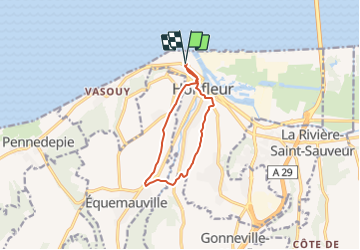

Length
8.5 km

Max alt
105 m

Uphill gradient
177 m
Km-Effort
10.9 km

Min alt
5 m

Downhill gradient
177 m
Boucle
Yes
Creation date :
2022-04-10 16:37:43.694
Updated on :
2022-04-10 16:38:32.249
2h28
Difficulty : Easy

FREE GPS app for hiking
 SityTrail
IGN / Geographical institutes
SityTrail Plus
The world is yours!
About
Trail On foot of 8.5 km to be discovered at Normandy, Calvados, Honfleur. This trail is proposed by Laurent53.
Positioning
Country:
France
Region :
Normandy
Department/Province :
Calvados
Municipality :
Honfleur
Location:
Unknown
Start:(Dec)
Start:(UTM)
299001 ; 5478433 (31U) N.
Comments