


P1

PhilippeC54
User
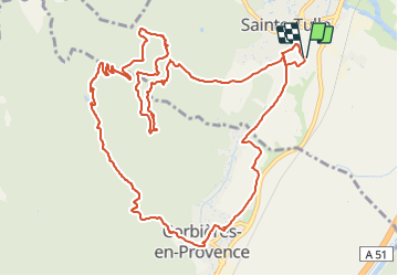

Length
15.6 km

Max alt
522 m

Uphill gradient
436 m
Km-Effort
21 km

Min alt
279 m

Downhill gradient
436 m
Boucle
Yes
Creation date :
2022-04-11 07:12:32.412
Updated on :
2022-04-11 10:26:57.046
2h04
Difficulty : Medium

FREE GPS app for hiking
 SityTrail
IGN / Geographical institutes
SityTrail Plus
The world is yours!
About
Trail Mountain bike of 15.6 km to be discovered at Provence-Alpes-Côte d'Azur, Alpes-de-Haute-Provence, Sainte-Tulle. This trail is proposed by PhilippeC54.
Positioning
Country:
France
Region :
Provence-Alpes-Côte d'Azur
Department/Province :
Alpes-de-Haute-Provence
Municipality :
Sainte-Tulle
Location:
Unknown
Start:(Dec)
Start:(UTM)
722579 ; 4851371 (31T) N.
Comments