


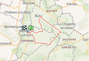
Montreuil sur Epte La Chapelle en Vexin

serge.guerroult
User

Length
11.1 km

Max alt
161 m

Uphill gradient
190 m
Km-Effort
13.6 km

Min alt
45 m

Downhill gradient
190 m
Boucle
Yes
Creation date :
2022-04-11 11:33:42.553
Updated on :
2022-05-03 07:30:46.691
3h48
Difficulty : Difficult

FREE GPS app for hiking
 SityTrail
IGN / Geographical institutes
SityTrail Plus
The world is yours!
About
Trail Walking of 11.1 km to be discovered at Ile-de-France, Val-d'Oise, Montreuil-sur-Epte. This trail is proposed by serge.guerroult.
Positioning
Country:
France
Region :
Ile-de-France
Department/Province :
Val-d'Oise
Municipality :
Montreuil-sur-Epte
Location:
Unknown
Start:(Dec)
Start:(UTM)
403634 ; 5447925 (31U) N.
Comments