


Wasserbourg-Munster A/R en VTT

nicolas54230
User
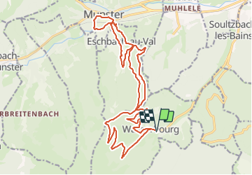

Length
22 km

Max alt
913 m

Uphill gradient
942 m
Km-Effort
35 km

Min alt
371 m

Downhill gradient
943 m
Boucle
Yes
Creation date :
2022-04-11 11:43:30.72
Updated on :
2022-04-11 11:44:15.904
2h25
Difficulty : Difficult

FREE GPS app for hiking
 SityTrail
IGN / Geographical institutes
SityTrail Plus
The world is yours!
About
Trail Mountain bike of 22 km to be discovered at Grand Est, Haut-Rhin, Wasserbourg. This trail is proposed by nicolas54230.
Positioning
Country:
France
Region :
Grand Est
Department/Province :
Haut-Rhin
Municipality :
Wasserbourg
Location:
Unknown
Start:(Dec)
Start:(UTM)
363018 ; 5318180 (32U) N.
Comments