


bertin

canal
User
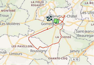

Length
12.7 km

Max alt
179 m

Uphill gradient
92 m
Km-Effort
13.9 km

Min alt
131 m

Downhill gradient
85 m
Boucle
No
Creation date :
2022-04-11 08:34:51.285
Updated on :
2022-04-11 13:12:44.284
4h37
Difficulty : Difficult

FREE GPS app for hiking
 SityTrail
IGN / Geographical institutes
SityTrail Plus
The world is yours!
About
Trail Walking of 12.7 km to be discovered at Ile-de-France, Essonne, Gometz-la-Ville. This trail is proposed by canal.
Description
aerotrain
Positioning
Country:
France
Region :
Ile-de-France
Department/Province :
Essonne
Municipality :
Gometz-la-Ville
Location:
Unknown
Start:(Dec)
Start:(UTM)
435566 ; 5391037 (31U) N.
Comments