


mon balcon de Céret

stef789
User GUIDE
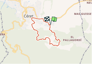

Length
6.9 km

Max alt
436 m

Uphill gradient
268 m
Km-Effort
10.5 km

Min alt
165 m

Downhill gradient
272 m
Boucle
Yes
Creation date :
2022-04-11 12:17:34.631
Updated on :
2022-04-11 15:14:17.343
2h55
Difficulty : Easy

FREE GPS app for hiking
 SityTrail
IGN / Geographical institutes
SityTrail Plus
The world is yours!
About
Trail Walking of 6.9 km to be discovered at Occitania, Pyrénées-Orientales, Céret. This trail is proposed by stef789.
Photos


22 photos in total. Please click on a photo to see them all in the gallery.
Positioning
Country:
France
Region :
Occitania
Department/Province :
Pyrénées-Orientales
Municipality :
Céret
Location:
Unknown
Start:(Dec)
Start:(UTM)
480580 ; 4703249 (31T) N.
Comments