


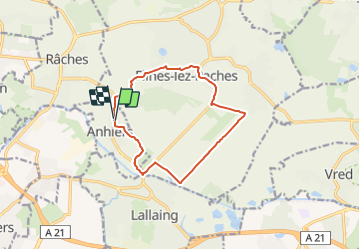
Boucle d'Anhiers par le marais d'Auchy

BrassensJC
User

Length
10.7 km

Max alt
26 m

Uphill gradient
39 m
Km-Effort
11.2 km

Min alt
14 m

Downhill gradient
38 m
Boucle
Yes
Creation date :
2022-04-12 12:31:45.741
Updated on :
2022-04-12 12:34:53.093
2h32
Difficulty : Medium

FREE GPS app for hiking
 SityTrail
IGN / Geographical institutes
SityTrail Plus
The world is yours!
About
Trail Walking of 10.7 km to be discovered at Hauts-de-France, Nord, Anhiers. This trail is proposed by BrassensJC.
Positioning
Country:
France
Region :
Hauts-de-France
Department/Province :
Nord
Municipality :
Anhiers
Location:
Unknown
Start:(Dec)
Start:(UTM)
511061 ; 5583922 (31U) N.
Comments