


P4 raccourcir

PhilippeC54
User
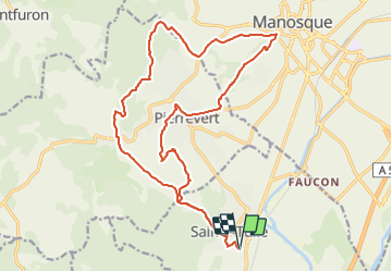

Length
23 km

Max alt
558 m

Uphill gradient
576 m
Km-Effort
31 km

Min alt
297 m

Downhill gradient
576 m
Boucle
Yes
Creation date :
2022-04-12 12:18:03.198
Updated on :
2022-04-12 15:27:55.644
2h13
Difficulty : Difficult

FREE GPS app for hiking
 SityTrail
IGN / Geographical institutes
SityTrail Plus
The world is yours!
About
Trail Mountain bike of 23 km to be discovered at Provence-Alpes-Côte d'Azur, Alpes-de-Haute-Provence, Sainte-Tulle. This trail is proposed by PhilippeC54.
Positioning
Country:
France
Region :
Provence-Alpes-Côte d'Azur
Department/Province :
Alpes-de-Haute-Provence
Municipality :
Sainte-Tulle
Location:
Unknown
Start:(Dec)
Start:(UTM)
722585 ; 4851374 (31T) N.
Comments